Coal Creek Historic Park
This page was last reviewed on February 2, 2026.
This 40 hectare park is located west of the Village centre on Comox Lake Road.
The sites of the historic Chinatown, No. 1 Japanese Town site, the No. 1 and No. 2 coal mine sites are within the park. The South Wellington Colliery Railway trail also travels through the park.
Parking and Access
The park has two small parking lots accessed from Comox Lake Road
- To access the historic Chinatown site there is a small parking area off Comox Lake Road near Jumbo’s cabin.
- You can also enter the park at the No. 1 Japanese townsite sign on Comox Lake Road to access a second parking area.
The park can also be accessed by bike or on foot through the Cumberland Community Forest trail system or from the west end of Dunsmuir Avenue (Camp Road) or Comox Lake Road. View a map of community parks on the parks page.
Walking Tours
View the brochures for the
Brochures may also be available at the park.
Park Master Plan
A Coal Creek Historic Park Master Plan was completed on July 14, 2014 to guide the future development of the park.
Disc Golf Course
Coal Creek Historic Park is home to an 18 hole disc golf course located 250m to the south of the Chinatown Historic site. The course is maintained in partnership with the Comox Valley Disc Golf Club (CVDGC). Find out more.
History of No.1 Japanese town (1893-1942)*
As early as December 1891 Japanese miners settled one and a half miles west of the town of Union to work in #1 Mine of the Union Colliery Company (UCC). The Dunsmuir family operated UCC, opening #1 in 1888. Worldwide depression caused closure of the mines, including #1 through most of 1892 and all but one resident returned to Japan.
By 1893 the community was rebuilding. The Japanese miners were able to bring their families with them, unlike the Chinese who were subject to the prohibitive federal head tax. Up to 36 homes and businesses, a bathhouse plus two general stores made up the small community, bounded by Coal Creek (Ura No Kawa) to the south and west, the coal tailings pile (Taka Yama) to the east, and the Wellington Colliery Railway to the north. A rough baseball diamond dominated the open space with baseball a popular pastime. Taka Yama provided a backstop in the summer months and a sledding hill in the winter. Ura No Kawa was a popular swimming hole and had a wooden bridge connecting the community to vegetable gardens on the other side. This photograph by Mr. Mas Tsuruoka (circa 1939) at the entrance gate shows a view of the community from the tailings pile.
Children attended schools in Cumberland as well as Japanese language school 6 days a week. A number of merchants established businesses in Cumberland over the years, and Japanese women had a traditional tea garden at Comox Lake from 1914-1939.
Japanese and Chinese miners were paid half the wages of their co-workers and suffered job losses in economic hard times. 1922 provincial legislation prevented their being employed in pulp or paper mills and the 1923 Oriental exclusion Act prevented them from working underground. In 1940 provincial legislation closed all foreign language schools. Despite these and other hardships this prominent Japanese community flourished for 49 years until the enactment of the Federal War Measures Act by the Government of Canada in 1942. Along with the residents of No. 5 Town and the Royston Sawmill, thirty-one families of No. 1 Town were ordered to leave with only what they could carry. They were transported by ship from Union Bay to Hastings Park in Vancouver then removed to internment camps (Kaslo, New Denver, Tashme, Roseberry, Slocan City, Lemon Creek, Sandon, and Greenwood). Japanese were barred from returning closer than 300 miles from the West Coast for five years after WWII ended. Despite promises by government, possessions were confiscated and sold soon after the internment. Buildings were later torn down or moved, and bottle diggers and treasure hunters dug up the former town site. Former No. 1 Town residents settled across Canada, many in the greater Toronto area.
Weldwood Canada purchased the property from Wellington Collieries. In 2002 a 104 acre parcel of land including the No.1 Japanese Town and Chinatown was gifted to the Village of Cumberland. It was named Perseverance Creek Historic Park, dedicated to the memory of the early Chinese and Japanese settlers who lived and worked there. Several committees worked on plans for the park. In 2007 the Village of Cumberland adopted in principle a Park Projection Plan and appointed the current Advisory Committee. The Committee consults closely with both former resident groups. At their request, the name was changed in 2008 to Coal Creek Historic Park, the name the creek was known by until 1947.
In 2009 to symbolize the thirty-one families who were forcibly removed in 1942, the equivalent number of Mt. Fuji flowering cherry trees was planted. A bronze plaque honouring these families was unveiled in May 2010. This project was made possible through the generous support of the National Association of Japanese Canadians and donations of former residents and their families. This project exists to bridge cultures, to honour a community that was integral to the development of Cumberland, and to acknowledge a history that includes racism, fear, and injustice. It exists to ensure that the important stories and lessons are not forgotten and, as part of an ongoing process of reconciliation and healing, that these types of actions are not repeated.
Future plans include an Asian-style bridge and traditional Torii welcoming gate on the rail grade leading to Chinatown; acquisition of the Saito House- the only original home remaining on the site; restoration of 53 heritage fruit trees; and marking of home locations. Some, identified by visiting former residents, are marked with small stakes, as are the two stores. Walking paths are being cleared where the two main roads ran east to west, as well as shortcuts between them. The cherry trees line the main access road to the site and these two roads. When mature the trees will spread up to 50′, their tops reaching each other. More information on No. l Town is available at the Cumberland Museum and Archives. The Japanese Cemetery is located on Union Road, which connects Cumberland and Royston Roads leading into Cumberland.
*Sources: Cumberland Museum and Archives, Cumberland Heritage by Jennifer Nell Barr, and discussions and correspondence with former residents and descendants. Additional reference: Watada, Terry. 2006. The Japanese Exclusion.
http://www.collectionscanada.gc.ca/immigrants/021017-2420-e.html
History of Cumberland Chinatown (1888-1968)
Cumberland’s Chinatown was built on wetlands just west of the settlement of Union on the east coast of Vancouver Island. Chinese workers were brought in by the Dunsmuir family (Union Colliery Company) to build and then work in the mines and to build the Wellington Colliery Railway to transport the coal to the seaport of Union Bay. At the site of #2 mine (1891-99) they drained the swamp; built houses, businesses and market gardens; and became one of Canada’s largest Chinese communities by the end of WWI. Over the course of the town’s existence, 100 Chinese miners were lost in coal mining disasters, and many suffered losses from flood and fires, including one in 1943 that destroyed 43 buildings (one-third of the town). The Chinese were banned from voting in 1872 by the British Columbia provincial government. Subsequent legislation banned them from working on public works projects such as road building. They were barred from working in pulp and paper mills in 1922, and prohibited from working underground by the federal Chinese Immigration Act in 1923.
The head tax of $50 initiated in 1884 increased ten-fold to $500 by 1905. Paid half of the wages of their European co-workers, Chinese miners were hard pressed to repay the company loan of the head tax, send money home overseas and eke out a living. They worked in the worst conditions and were the first to be laid off in hard economic times. The Great Depression of the 1930s saw the end of mining jobs for Chinese workers and the population continued to decline into the 1960s, many moving to Vancouver. The tailings pile of No.2 mine (1888-1899) are barely visible in the forest on the southern boundary.
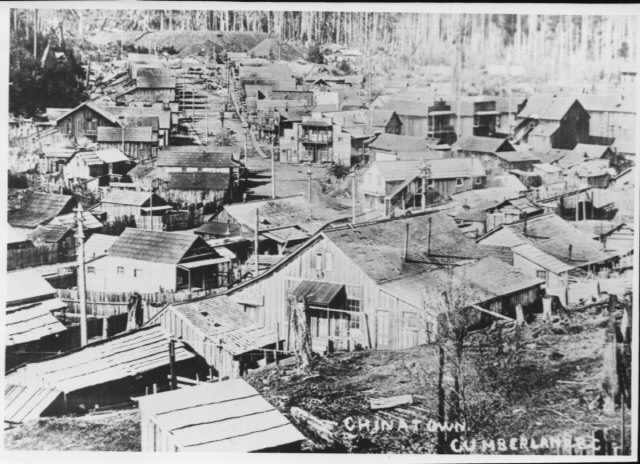
This Cumberland Museum and Archives photo shows Chinatown circa 1910.
In 1963 an unsuccessful attempt was made by the Village of Cumberland to get funding to restore the town as an historical tourist attraction. Through the 1960s bottle diggers and collectors ransacked what was left of the site. In 1968 the dilapidated buildings were razed, with the exception of the home of one elderly Chinese man Hor Sue Mah (Jumbo). Jumbo’s cabin was moved up the hill to Comox Lake Road where it remains today. The site was leased to Cumberland Rod and Gun Club until 2001.
A 104- acre property containing Chinatown and No. 1 Japanese Town was gifted to the Village of Cumberland by Weldwood Canada in 2002 with a restrictive covenant to protect its heritage and sensitive natural environment. A number of committees were struck to explore development of the park and a study commissioned to develop a plan. In 2007 the Park Projection Plan was adopted in principle by Cumberland Council and the Coal Creek Historic Park Advisory Committee appointed to recommend its implementation.
Cumberland Chinatown former residents and descendants have met yearly since 1972. From 1975 to 2006 they met in Stanley Park. Following extensive damage to the park they moved the event to Vancouver’s Riverside Park. Over 100 were in attendance at the 2010 reunion. The Advisory Committee consults with, and takes direction from the picnic reunion group on plans for the Park. At their request the name was changed in 2008 to Coal Creek Historic Park, the common name for the creek until 1947.
Little remains of this formerly thriving community other than Jumbo’s cabin. Several photo easels showing the buildings that once stood there have been created by descendant John Leung. The picnic pavilion is situated at the junction of Hai Gaa and Shan Gai Roads, once a popular gathering place where news was posted on a public notice board. The pavilion will accommodate 4 picnic tables, welcoming visitors to rest, visit and enjoy the natural beauty of the forest and wetlands. Storyboards and photos will complete the structure, giving a sense of the historic community. The Advisory Committee holds regular work parties to clear the site of invasive broom and woody debris and to tend gardens at the entrance and in the open area to the south.
More information on Cumberland Chinatown is available at the Cumberland Museum and Archives. Please also visit www.thecumberlander.ca , Special Sections: Coal Creek Historic Park, for information on the work of the Coal Creek Historic Park Advisory Committee and a copy of the Park Projection Plan. The Chinese Cemetery is located on Union Road, which connects Cumberland and Royston Roads leading into Cumberland
If you have additional information or photographs please contact the museum staff or the chair of the Coal Creek Advisory Committee through Village staff. We welcome your contributions.
*Sources: Cumberland Museum and Archives, Cumberland Heritage by Jennifer Nell Barr, discussions and correspondence with former residents and descendants.
Search again